
December 8, 00:00HRS PHT:
Typhoon Ruby is now on its way to southern Luzon. Reports received say that the strong winds at Leyte and Samar have eased already.
Bohol has electrical service as of December 7, 10:50 pm.
This is the last update about the forecast of Typhoon Ruby on This website.
December 7, 18:00HRS PHT:
Typhoon Ruby at last has moved away from Samar and is now moving west northwest heading to South Luzon. It has weakened to 140kph but is still moving slowly at 10kph.
Bohol is plunged into a total blackout since noon today.
So far Bohol was spared but the blackout will be a problem if not electricity service is not restored soon.

Latest forecast from JMA showing Ruby on a west northwest path.

Latest satellite image from PAGASA.
December 7, 09:00HRS PHT:
Typhoon Ruby has weakened as expected after landfall but it is still a dangerous typhoon as the winds near the center is estimated at 140kph. It is also moving very slowly to the west so the amount of rainfall will possibly cause flooding, flashfloods and landslides.
Bohol is currently experiencing only light winds and scattered rainshowers. The province has cloudy skies.
Electricity is already out though. Water service is also out in many areas in Tagbilaran City.

Latest satellite image from PAGASA.
December 7, 03:00HRS PHT:
Bohol is currently plunged into darkness as Typhoon Ruby batters Samar with 180kph winds while moving west at 10kph.
December 6, 21:00HRS PHT:
Typhoon Ruby has officialy arrived already making landfall in Dolores, Eastern Samar. The Japan Meteorological Agency reports the wind speed near the center at 180kph while the storm is moving west at 15kph. Images and videos posted on social media be residents at Samar and Leyte showed toppled electric posts, inundated seacoast and strong winds.
Bohol so far appear to be relatively safe as of this hour which only scattered rain showers in Tagbilaran City and other towns. Our prayers for the safety of our fellow Filipinos at Samar and other areas that will be severely affected by the storm.

Satellite image of typhoon Ruby at 21:00HRS PHT from PAGASA.

JMA forecast path still shows a westerly movement just avoiding Manila. The capital isl still expected to get heavy rainfall though.
December 6, 12:00HRS PHT:
Interestingly, typhoon Ruby is close to making landfall, or has started to do so, but the forecast models from JMA and PAGASA still do not agree on the exact landfall area and the path for the next three days. However, the forecast landfall areas from the two models are already close enough that we can say with certainty that Eastern Samar will get the full force of the typhoon makes landfall.
The next area of interest after landfall would be where the typhoon would pass across the country. The PAGASA forecast shows it will hit close to Manila while the JMA forecast shows a more southern path.
Given this scenario, residents of the coastal areas of eastern Samar should be fully ready by now with provisions, house strengthening, tree trimming and have evacuated if they are in areas at risk of storm surges and flooding. Residents from the provinces where the two forecast models say Ruby would pass through should get ready as well.
Typhoon Ruby is now classified to be “VERY STRONG” by the JMA from “VIOLENT” last night which means it has become somewhat weaker but potential for damage is still there. Winds are at 180kph near the center. Because tyhpoon Ruby is moving west or west northwest very slowly at 10kph, it means it will dump a lot of rain and can cause flooding, flash floods, landslides and mudslides. Everyone should be alert especially that it will make landfall later tonight.
While Bohol may not get the worst of the typhoon, electrical service interruption may happen because the NGCP or National Grid Corporation of the Philippines transmission lines and the Leyte Geothermal Plant may experience failures. Boholanos should still make emergency preparations, mobile devices and extra batteries should be charged and fuel for generators should be ready.

PAGASA forecast shows landfall on the northern part of Samar. It also shows that Metro Manila may be along the path

The Japan Meteorological Agency forecast still shows a slightly more southern landfall and path.
December 6, 00:00HRS PHT:
Both PAGASA and Japan Meteorological Agency are reporting landfall of super typhoon Ruby (HAGUPIT) at Eastern Samar. Storm surge is expected at the landfall area while heavy rains are expected throughout the “rain band” of the storm. Aside from Samar, southern Luzon will also take a lot of Ruby’s fury. Due to the amount of rainfall expected, flash floods and flooding should be expected in vulnerable areas.
The Guam Weather Forecast Office is no longer publishing forecast information so we are now relying on PAGASA and JMA for forecast information.

JMA forecast

PAGASA forecast
December 5, 18:00HRS PHT:
Landfall in 24 hours at Eastern Samar. Our thoughts go to the people of Samar, may they be safe and out of harm’s way as typhoon Ruby makes landfall. JMA forecast path still slightly lower than Guam WFO but matches with PAGASA forecast.

Latest forecast path by JMA.

Latest satellite image by PAGASA.
December 5, 15:00HRS PHT:
Forecasts from JMA, PAGASA and Guam WFO are virtually the same as earlier this morning. More details might be available later tonight. For now, Southern Luzon is now well in the path of the typhoon with landfall at Eastern Samar. Disaster preparations should have been completed by this time at these areas.
It seems Bohol and other provinces at the southern part of the Visayas and northern Mindanao will be spared from the worst of the typhoon. Typhoon Ruby also has lower wind speed near the center as of 15:00HRS PHT forecast from JMA which will certainly help lessen the damage but flooding, landslides and storm surge are still possible.
December 5, 09:00HRS PHT:
The JMA and Guam WFO are now close on their predictions of where super typhoon Ruby would make landfall and that is somewhere on the upper half of Samar. Southern Luzon is now definitely on the sites of the typhoon and citizens throughout this area, including Manila and parts of northern Luzon should make preparations.
Ruby is currently estimated to have winds up to 180kph near the center, a bit less powerful than what was estimated yesterday. It has maintained its slow approach to the Philippines at 15kph west northwest.
It looks like Bohol may be spared from the worst effects of the typhoon although it is likely that power interruption can happen since the province is connected to the national grid via Leyte. Leyte will be closer to the landfall area and may get its fair share of winds and heavy rains and thus may cause electricity sevice interruption.
The sun is currently out against cloudy skies in Tagbilaran City.
Shown below are the different forecast paths of typhoon Ruby from various agencies.

Guam WFO forecast path.

NOAH (Philippines) forecast path and typhoon advisories.

JMA forecast seems to be in agreement with PAGASA forecast.
December 5, 06:00HRS PHT:
The Guam WFO model for super typhoon Ruby’s forecast path still shows the typhoon will make landfall in northern Samar and eventually reach Manila while the JMA model shows the typhoon make landfall at southern Samar and move through the center of the country. The whole province of Samar should expect that the landfall will be anywhere on the eastern side of the province. The two models still have not converged but are much closer now versus the previous days.
The PAGASA forecast path seems to be a hybrid of both JMA and Guam WFO forecasts showing landfall at northern Samar and following a more westward path compared to the Guam WFO forecast, ending up on a similar location as the JMA forecast.
The JMA forecast may change to have a more northwards path later today.
Bohol and other provinces with Signal #1 and #2 warnings will start to experience cloudy conditions with some rain and possibly some windy condition starting today. The satellite image from PAGASA already shows a huge part of the eastern side of the Philippines will get heavy rainfall.

PAGASA forecast path of typhoon Ruby

Guam WFO forecast

Guam WFO forecast

Japan Meteorological Agency forecast.

PAGASA satellite image showing heavy rain is to be expected on the eastern side of the country today.
December 5, 00:00HRS PHT:
Finally, the JMA model and the Guam WFO model have nearly converged in their forecast path for typhoon Ruby (HAGUPIT international name). The latest forecast from Guam WFO shows the path significantly lower than earlier forecasts, this time landfall is expected in northern Samar. The JMA forecast has moved slightly northwards but is still showing that landfall will happen in southern Samar.
Both forecasts will likely converge within 24 hours as the weather dynamics will become more certain for both forecasting models. While Bohol and other provinces south of Visayas will be spared from the worst of the storm, residents of southern Luzon must get ready as the typhoon is highly likely to head their way.
Metro Manila may experience heavy downpour and flooding should be expected in low lying areas. Residents of Visayas, especially those in the eastern part of the region should already have emergency provisions ready. Structures that may be affected should be strengthened, trees trimmed, water ways cleared and evacuation plans reviewed.
As super typhoon Ruby approaches the country, let us all pray that everyone will have sufficient preparations to avoid casualties. Keep safe, everyone.

Guam WFO forecast path is now showing landfall in northern Samar with the typhoon bearing down to Manila.

Guam WFO forecast path and possible areas that may be in the storms path if conditions change.

The JMA forecast path now shows a significant change northwards.
December 4, 21:00HRS PHT:
The forecast from JMA now shows that typhoon Ruby will make landfall in Samar. This is definitely showing signs of converging with the Guam WFO forecast. The PAGASA forecast is in between the JMA and Guam WFO forecast.
Bohol and the rest of the Visayas will still see heavy rainfall and strong winds so emergency preparations should be in place the latest on December 5.

JMA forecast now shows landfall happening in Samar.

PAGASA forecast path shows northern Samar as the landfall area.

Satellite image of typhoon Ruby. Red is intense rainfall.
December 4, 18:00HRS PHT:
Forecast from JMA still shows typhoon Ruby will make landfall in Leyte while Guam WFO shows it will traverse the eastern seacoast of the country before travelling westward towards Luzon. For some reason, the PAGASA website is still down so no new forecast from their website can be downloaded. A copy of a PAGASA bulletin published by netizens on Facebook is shown below but it is from yesterday.
In a nutshell, the JMA, Guam WFO and the PAGASA forecast paths for super typhoon Ruby have not converged yet although it is clear now that Bohol may be spared from the worst of the impact of the typhoon. However, super typhoon Ruby will be moving to the west slowly and will bring very heavy rainfall. Flooding, landslides and flash floods may be possible in some areas.
Even though the forecasts are not in agreement, they have become closer than the past few days. The Guam WFO forecast at 5PM PHT (7PMChST) shows the track nearer the eastern coastline and may enter the country in Luzon instead of proceeding to Japan. The JMA forecast path is slightly towards the north than in previous days.
Storm Signal#1 is in effect already for Bohol and other provinces in Visayas and Southern Luzon. Classes at all levels for December 5 are already suspended.
Residents in Northern Mindanao, Visayas and Southern Luzon should ensure that preparations for the coming storm are done. Emergency provisions, medical kits, drinking water, electronic devices and extra batteries should be fully charged, gasoline or diesel for generators should be ready also.

Guam WFO forecast still showing that typhoon Ruby will not hit landfall in the Visayas but instead in Eastern Luzon.

JMA foreast still shows the storm traversing the Visayas and making landfall in Leyte.
PAGASA forecast (copied from social media posts) is in agreement with the JMA forecast.
December 4, 12:00HRS PHT:
Forecast from JMA shows no change from the previous forecast except for the expected location of the storm on December 5. The GUAM WFO however, is showing that their model is tracking typhoon Ruby towards Luzon. As of this hour, it is still uncertain where typhoon HAGUPIT (international name of Ruby) will pass. The different models used by these agencies will eventually produce a similar forecast when effects of the the various elements of the weather system become clearer. At this time, a cold front from the northeast of the Philippines is expected to have a significant impact on the direction and strength of the typhoon. Again, however, it is still unclear how the typhoon will behave in response to the cold front.

GUAM WFO forecast path for Ruby shows it may hit landfall in Luzon instead of Visayas.

JMA forecast path of Ruby still is showing that it will make landfall in Leyte.
December 4, 09:00HRS:
The latest forecast path from the Japan Meteorological Agency now shows a more pronounced northwards direction of typhoon Ruby. It is no longer showing that it will hit close to Bohol, although the province is still within the probability of being along the path of the typhoon.

JMA forecast path for the next five days shows that typhoon Ruby will have a more northwards path and Bohol may not get directly hit. The slow movement of the typhoon could bring heavy rains and may cause flooding.
The JMA model still is not close to what the Guam Weather Forecast Service model is showing. The two agencies use different forecast models that shows different results. Because the typhoon movement to the west has slowed down, the typhoon is expected to linger much longer and if it hits landfall, heave rains would be expected along its path.
Preparations for the coming natural disaster should be in full swing by now.
December 4, 06:00HRS:
Ruby’s path is still up for debate with two models diverging in their forecast between Dec 4 and Dec 5. The Japan forecast is now showing landfall sometime on December 6 while the US/Guam forecast shows the path avoiding the Visayas area and perhaps traversing the sea coast on the eastern side of the country. What is clear is that the storm’s movement towards the Philippines has slowed down but the typhoon strength has increased to 160kph near the center. It is forecast to strengthen up to 180 kph near the center.
Citizens living near the coastal areas of the eastern side of the Philippines should start to make preparations for the storm. Those living in the Visayas and Southern Luzon should get ready with provisions, clear waterways, and strengthen roofs, windows and doors. Floods are possible even if the storm doesn’t pass through the country because the storm is expected to bring heavy rains.

Track from the Guam Weather Forecast Office shows the storm could curve northwards in the next few days.

Track from the Guam Weather Forecast Office shows the storm could curve northwards in the next few days. This graphic shows the possible areas of strong winds.

The Japan Meteorological Agency forecast shows the storm making landfall in Leyte and moving west towards Palawan.
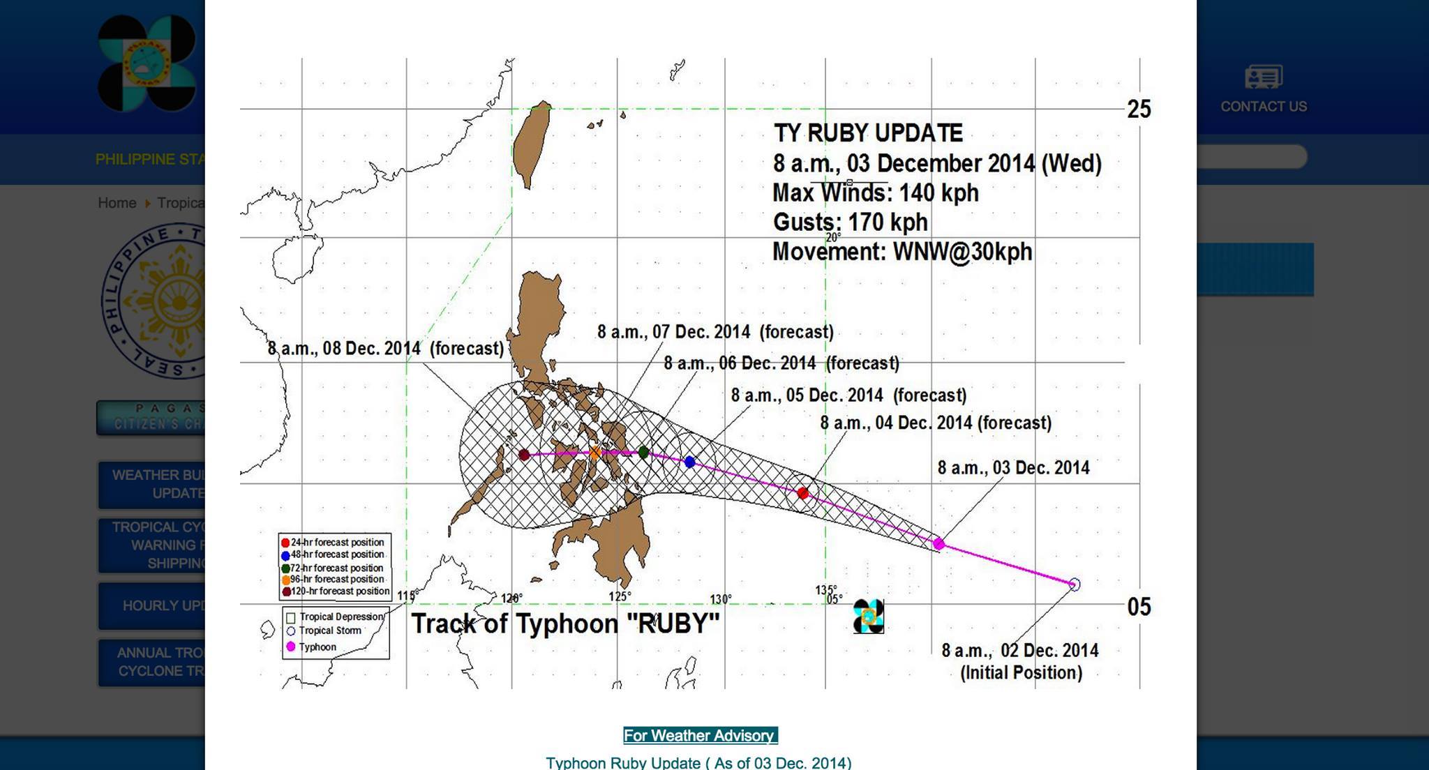
December 3, 12:00HRS:
Ruby’s path is still not 100% certain to hit the Philippines but various forecast tracks seem to indicate that the strong typhoon will make landfall in Leyte or Samar. The available forecast data are shown below. Preparations mentioned in the Dec 3, 09:00HRS update should be done by residents in the areas along the possible path of Ruby.

Japan Meteorological Agency forecast at 12:00HRS PHT still indicate that typhoon Ruby will hit the eastern Visayas. The path is slightly higher versus the previous forecast which is good news for Boholanos since the province may avoid the brunt of the storm.

Forecast data from the Guam Weather Forecast Office shows a more northwards path of typhoon Ruby.

Another forecast analysis of typhoon Ruby from the Guam Weather Forecast Office shows a more northward path but Ruby may still hit the eastern part of the country.
As of this update, it is still uncertain where the typhoon will make landfall. It may veer north also as mentioned in previous updates.
December 3, 09:00HRS:
Typhoon Ruby’s path is still up for debate with the JMA reporting that it will cross the Visayas region. Other models as reported in www.westernpacificweather.com say that the storm may move northwards and avoid the Philippines. Residents in the Visayas should start preparations for the storm at this time. Even if it will go north, strong winds, rough sea conditions and heavy rain is still expected especially on the eastern side of the country.

Forecast path of Typhoon Ruby published by the Japan Meteorological Agency at 09:00HRS PHT.
The PAGASA still doesn’t have a track of the typhoon. At this time also, the US Joint Typhoon Warning Center website is down so we do not have an update from them. Their storm model is different from the one used by JMA so it would have been interesting to see what their model show for the storm track for the next few days.
The satellite image of PAGASA as of 09:00HRS PHT shows the storm size and the intense rainfall at the center. Contrary to text messages and fake reports circulating on social media, the storm is not going to be stronger than Yolanda, the strongest storm to ever make landfall in recorded history worldwide. Nevertheless, residents in the Visayas region should start preparations as soon as possible. Trees should be trimmed, roofs reinforced, food and water reserves for a few days should be stored and batteries and devices should be charged. Electricity service interruption is expected if the storm makes landfall in Leyte as it will hit power lines of the NGCP. Bohol will likely have no power for a few days if transmission lines will get damaged again just like after Yolanda.

PAGASA satellite image as of 09:00HRS PHT.
December 2, 21:00HRS:
Typhoon Ruby’s path as it nears the PAR is still uncertain. Filipinos hope that the typhoon will move northwards and avoid the country altogether.
Japan Meteorological Agency updated it’s 5-day forecast path of the typhoon as of 21:00HRS. The path is now slightly higher compared to the 18:00HRS update. Boholanos continue to hope that the province will be spared from harm in the coming weekend.

December 2, 2014, 21:00HRS update of the forecast path of “Ruby”.
In Accuweather.com’s weather update earlier today, they stated that:
“It remains unclear exactly where Hagupit will ultimately end up, but it is increasingly likely that at least some impact will be felt across the northern Philippines. Model guidance suggests that wind shear may increase later this week, potentially weakening the storm before a potential landfall. We’ll continue to monitor the progress of this system.”
The PAGASA weather satellite update as of 21:00HRS PHT clearly shows typhoon Ruby already looking like a threat bringing along heavy rainfall aside from the forecast 170kph winds.

PAGASA weather satellite image at 21:00HRS PHT. Typhoon Ruby is shown on the lower right of the image.
December 2, 18:00HRS:
Typhoon Ruby (International name: Hagupit) was last located at 2,325 kilometers east of Mindanao according to the Philippine Atmospheric, Geophysical and Astronomical Services Administration (PAGASA).
The storm has maximum wind velocity of 75 kilometers per hour near the center with gusts up to 90kph. Forecast data shows a west northwest movement at 35kph.

Forecast path of tropical storm ‘Hagupit’ based on the data from the US Joint Typhoon Warning Center.

Forecast path of Typhoon Ruby from the Japan Meteorological Agency shows that it may possibly hit the Visayas region and could impact Leyte, Bohol and Cebu.
PAGASA senior weather forecaster Rene Paciente said Hagupit may enter the Philippine Area of Responsibility (PAR) by Thursday noon. Paciente said the storm may make landfall in Eastern Visayas and traverse through the central part of the country. However, it still has the possibility of moving northwards to Japan and avoid the country altogether.
Before it makes a possible landfall, Hagupit will have maximum sustained winds of 150 kph to 175 kph. It will dump moderate to intense rains to the areas along its track and may generate storm surges of up to 4 meters.
Coastal waters along the eastern seaboard of Southern Luzon, Visayas and Northern Mindanao will be rough to very rough.
Landrico Dalida Jr., PAGASA’s officer-in-charge for operations and services, said Hagupit may not intensify into a super typhoon based on their data available at this time.
December 2, 2014:
A new tropical depression has developed 3,200kms east of General Santos City yesterday and is currently moving westward at 35km/hour towards Southern Leyte. However, due to the distance of its current position, it is still not possible to determine its landfall area in the country. When it enters the Philippine Area of Responsibility or PAR, it will be called “Ruby”.
Contrary to some reports on social media and text messages, there is no typhoon “Seniang” yet.
If the high pressure area over the Philippine Sea or above the tropical depression continues, Ruby might hit the Visayas regions. Otherwise, it will take a northwards direction and hit the northern regions of the country.

Current forecast path of tropical depression Ruby (Hagupit International Name) as of 8:00AM PHT from the Japan Meteorological Agency website (http://www.jma.go.jp/en/typh/1422.html).